Africa is slowly splitting into two continents, and scientists say a new ocean could eventually form « the evidence and the video explained »
The idea sounds like science fiction: a continent tearing apart and a brand‑new ocean filling the gap. But this is exactly what geologists say is happening in East Africa. The process is slow — measured in millions of years — but a growing body of evidence and striking satellite and field footage make it clear that continental rifting is underway.
What is happening and where?
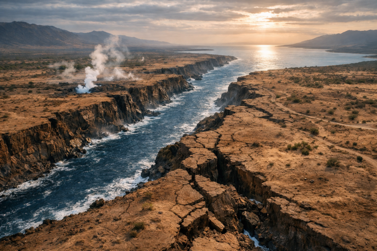
The phenomenon is centered on the East African Rift System (EARS), a zone of crustal extension that stretches from the Afar region in northeastern Ethiopia down through Kenya, Tanzania and beyond. The rift marks the boundary between the Nubian Plate (western Africa) and the Somali Plate (eastern Africa). In the Afar Triangle these plates meet the Arabian Plate at a triple junction where rifting, seafloor spreading and volcanic activity combine.
As the continental crust thins and pulls apart, magma rises from the mantle, forming volcanic chains, fissures and faults. Over geological time, continued extension can evolve from continental rifting to seafloor spreading — the hallmark of a new ocean basin.
The evidence: geology, earthquakes, and satellites
Multiple lines of evidence show active rifting:
- Seismic activity: Frequent earthquakes along rift faults reveal ongoing brittle deformation as the crust is stretched and breaks.
- Volcanism and fissures: Repeated eruptions and magma intrusions create long dykes and surface fractures. A famous example is the Dabbahu (Manda Hararo) rifting event in 2005, when magma intruded tens of kilometers and opened surface fissures measuring up to meters in width.
- Ground deformation measured by GPS: Continuous GPS stations across the rift record divergent motion — typically a few millimeters to a few centimeters per year — consistent with plates slowly moving apart.
- Satellite radar (InSAR) and aerial imagery: Interferometric synthetic aperture radar detects subtle uplift, subsidence and lateral shifts over time. Time‑lapse and before‑and‑after satellite images make these invisible motions visible to the naked eye.
- Geological mapping: Rock types, fault orientations and volcanic deposits preserve a history of progressive thinning and break‑up of the continental crust.
Taken together, these observations paint a consistent picture of an active rift that could, given millions of years, become a true ocean basin.
Why a new ocean could form
Not every rift ends in an ocean. Some rifts fail and become inactive. But where extension is sustained — and where mantle upwelling supplies magma to create new oceanic crust — rifting can transition into seafloor spreading.
In the Afar region the conditions are favorable: existing adjacent oceanic spreading in the Red Sea and Gulf of Aden already show how continental crust can be transformed into oceanic crust. If the East African Rift continues to open for millions of years, the gap between the Nubian and Somali plates could be invaded by seawater and eventually develop typical oceanic crust, effectively creating a new ocean and splitting Africa into two distinct landmasses.
How long will it take?
Timescales are extremely long. Contemporary rift rates are slow — a few millimeters to centimeters per year — so the full process of forming an ocean would likely take millions to tens of millions of years. Scientists typically talk in terms of geological epochs rather than human timeframes: the initial stages are visible now, but a true ocean would require sustained extension over many millions of years.
The video evidence explained
Recent videos and animations combine field footage, drone clips, and satellite imagery to illustrate rifting in dramatic fashion. Common elements in the most informative videos include:
- Time‑lapse sequences of volcanic eruptions and lava flows.
- Satellite sequences showing ground displacement over months or (Incomplete: max_output_tokens)